


Orienteering games are fun for everyone. Activities can be set up using the floor plan in a school or municipal center when the weather is not so great for being outside. The goal of organizing a fun activity using maps is to have the participants gain confidence figuring out where they are and how to get where they want to go. Orienteering provides a unique lesson for focusing on what one is doing rather than what everyone around them is doing. The first step, though, is the map. It’s gotta be real.
Waterville Valley’s Nordic Center, in Waterville, NH, hosted a Family Fun Weekend featuring orienteering and treasure hunts on skis. We were asked to set up a course on their trail map. They assured us that we wouldn’t need to invest the time in mapping as they had ‘GPSed’ the trails and we could simply hang our controls and put the circles on the map.
Well, I wish it was that simple. The thing about orienteering maps is they need to be adjusted to magnetic north, have a usable scale, and they need to describe all trails and nuances in the landscape. If the participants venture out to find their controls and the trails don’t match what is on the paper, they will be frustrated. They will find very little satisfaction in completing the course. It is important to fix the trail map before you call it an orienteering course.

I use OCAD software to make maps, but you can adjust a trail map in other types of drawing software. Here is how you can do it:
- Go out on the trail map and find magnetic north with a compass. Stand at an obvious road junction. Hold a compass in front of you and determine a straight line between you and another object on the map. Sometimes it is a bend in the road, building or trail head.
- Back at the computer, open the software and open a digital version of the trail map. Use that magnetic line that you just made and rotate the map until the the line is parallel with the printed edge of the map.
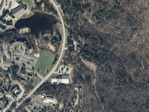
- Go to Google Earth and find the map location. Go to the top of the page and turn back the history dial until an aerial image is revealed that shows a leaf-off version so you can see the roads and buildings. Use the line drawing tool in Google Earth to measure a 100 meter line between two convenient objects. You can pick buildings, parking lots, edges of vegetation or other definitive spots that you will be able to find in the real world. I also make a 500 meter line. Export that view to your editing software.
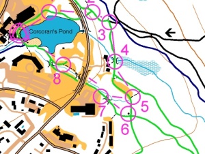
- Open that saved image in your editing software. Open the digital version of the trail map in a transparent layer so you can see the Google image through it and adjust the trail map to fit. Now, both maps will print to magnetic north. Great.
- Now, draw all of the objects that you see on the aerial view onto the trail map layer. Include all buildings, parking lots, vegetation changes, and water features. When all of that tracing is complete, print the map and take a walk. You need walk the entire map and hand draw all of the features that weren’t on the Google image. People are constantly changing the landscape. Or there may have been conifer coverage of areas and a building didn’t show on the computer that you need to draw. Walk the trails. Make sure you indicate small trails and snow shoe routes that aren’t on the trail map. They will matter to the ski orienteering youth that comes to a junction and wants to be sure which way to turn.
- Now you will need to resolve the scale. That 100 meter line you made in Google Earth works to determine the distance between real world objects on the map. Determine what area you really need to print. Don’t print the entire area if you are making a couple of short, easy courses.
Of course, this is a simplified version of the process. You can email me info@ultimatetreasurehunts.com with more questions. I am more than happy to come to you to create a map for your event. We have maps across the country in schools, public parks and private venues that are still being used to facilitate fun, family activities that educate and enhance any outing.
It really is okay to get lost. Figuring it out is the lesson. ultimatetreasurehunts #uthunts
